Shirleysburg stands in the Aughwick Creek valley on ground connected with some of Huntingdon County’s earliest recorded settlement. A trading post and frontier fort came first; farms, roads and a village followed. By the nineteenth century, Shirleysburg was the commercial center of a largely agricultural countryside.
1753
Croghan at Aughwick
1756
Fort Shirley Named
1837
Borough Incorporated
1873
East Broad Top Arrives
The Colonial Frontier
George Croghan and Fort Shirley
By 1753
A Trading Post at Aughwick
George Croghan, an influential frontier trader and diplomatic intermediary, established a trading post at Aughwick near the present borough. The location connected paths through the valley and became an early point of colonial activity west of the Susquehanna.
1755–1756
A Stockade Becomes Fort Shirley
As violence spread during the French and Indian War, Croghan’s stockade was strengthened by Pennsylvania as one of a chain of frontier defenses. Governor Robert Hunter Morris named it Fort Shirley in January 1756, honoring William Shirley, commander in chief of British forces in North America.
Frontier Garrison
A Base, Not a Battlefield
The fort reportedly held a garrison of about seventy-five men. No attack on Fort Shirley is documented, but it served as an assembly and supply point for Colonel John Armstrong’s 1756 expedition against Kittanning.
1762
The Oldtown Tract
A 424-acre tract called “Oldtown” was surveyed for Croghan after the fort era. Early accounts use Aughwick, Old Town and Fort Shirley for overlapping places, so researchers must distinguish the present borough from Little Aughwick and other nearby localities.
Where Was the Fort?
Historical accounts place the stockade near Fort Run, just north of the borough. The precise landscape has changed, and the surviving historical marker identifies the general site rather than a standing fort. Fort Shirley’s name lives on in both Shirley Township and Shirleysburg.
Community History
Finding Fort Shirley Beneath the Ground
Archaeology has added physical evidence to Shirleysburg’s written history. In a 2010 account, archaeologist Jonathan Burns reported a builder’s trench extending more than 95 feet and charred palisade timbers associated with the fort. Those discoveries helped establish the stockade’s position and construction.
Penn State’s 2013 field-school report described a cooking feature containing pig, sheep, turtle and fish remains, along with finds including a copper charm and a British gunflint. Such objects provide evidence of food preparation, daily life and the military presence, beyond the names and dates in older histories.
A Juniata College account of a 2015 exhibition explained that the fort’s usefulness ended in 1756. The excavation story therefore belongs to a short, specific period in the French and Indian War, not an assumed continuous military occupation.
A principal valley road—the ancestor of present-day U.S. Route 522—was laid out in 1774. Settlement increased after the Revolutionary War, when families established farms throughout the Aughwick Valley and a small commercial village grew near the old fort site.
1800
A local tannery
Thomas McVitty established a small tannery. Under later owners it became one of the borough’s most substantial enterprises, processing thousands of hides annually by the 1880s.
1830–1850
The strongest period of growth
Stores, taverns and workshops served nearby farms. Blacksmiths, tailors, wheelwrights, potters and other craftspeople made the borough the valley’s principal market town.
1837
Incorporated as a borough
The Pennsylvania General Assembly formally created the Borough of Shirleysburg during its 1836–37 session.
1844
A new gristmill
David Eby built a mill that replaced an earlier log mill and served the surrounding agricultural community.
1847
A village of 275
A mid-century account placed the population at about 275 people living in approximately thirty to forty houses.
Schools, News and Public Care
Institutions of a Nineteenth-Century Community
1850–1852
The County Almshouse
Huntingdon County constructed its almshouse just south of Shirleysburg. The institution and its associated farm became a major presence along the road below the borough.
Early 1850s
Two Private Academies
The Aughwick Collegiate School for Boys and Shirleysburg Female Seminary briefly made the village an educational center. Both closed within about a decade, but the Benjamin B. Leas House remains associated with the seminary and Fort Shirley site.
1855–1862
The Shirleysburg Herald
John Lutz published the local newspaper intermittently through the Civil War era. Original issues survive in the Fort Shirley Heritage Association’s collection and offer a rare window into borough life.
Churches and Schools
A Preserved Village Landscape
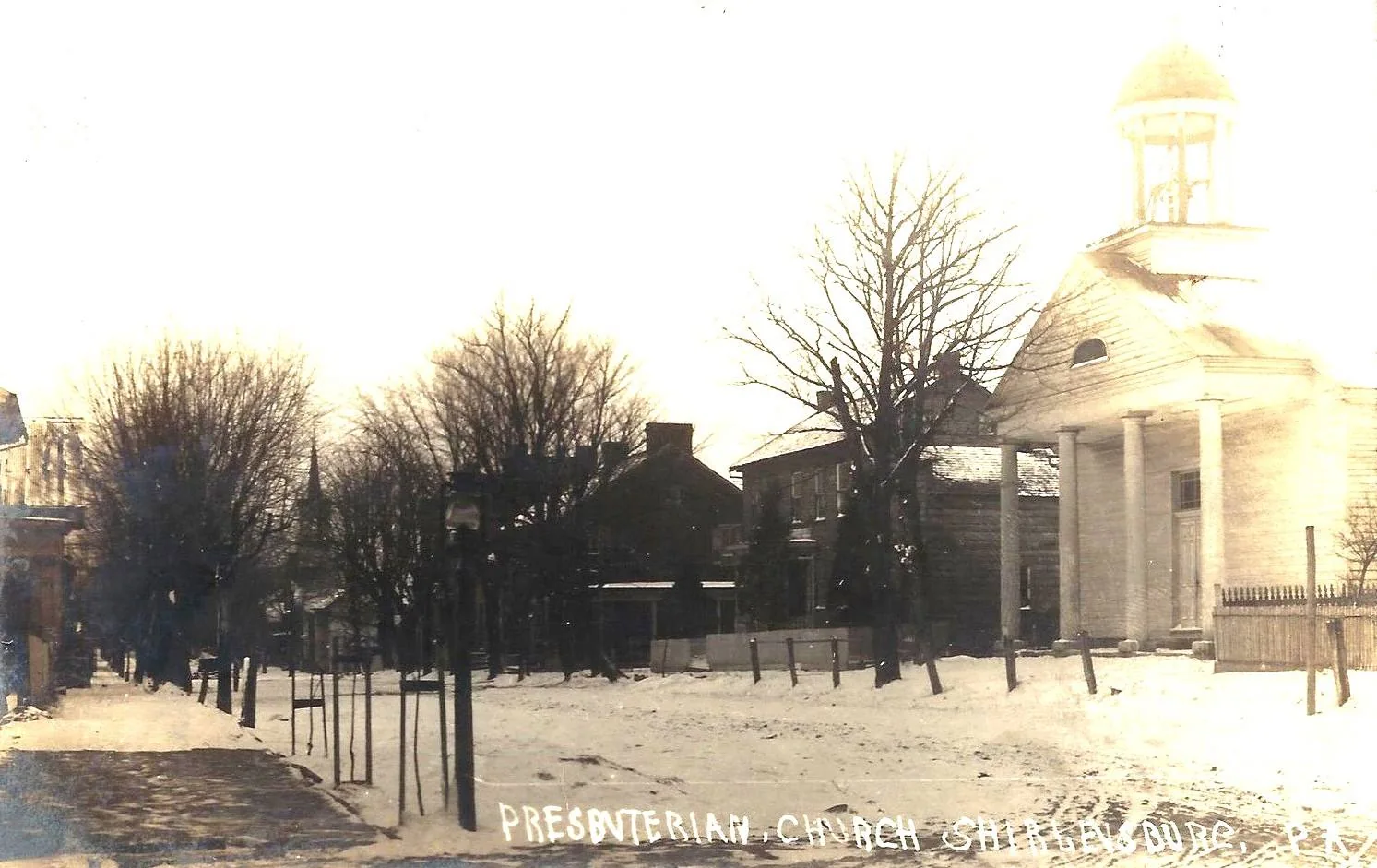
The former Presbyterian church of 1830, the 1877 United Methodist church and the two-story brick school built in 1880 contribute to Shirleysburg’s distinctly nineteenth-century appearance.
Shirleysburg and the Brown Family Case
Titus R. Wingert’s local study places the 1840 Brown family case within Shirleysburg’s orbit: the Brown farm lay southwest of town, Constable John Price held prisoners at his Shirleysburg home, and several officials and witnesses had borough connections. Read the carefully sourced account on The Brown Family Murders page.
The East Broad Top Era
A Narrow-Gauge Link Through the Valley
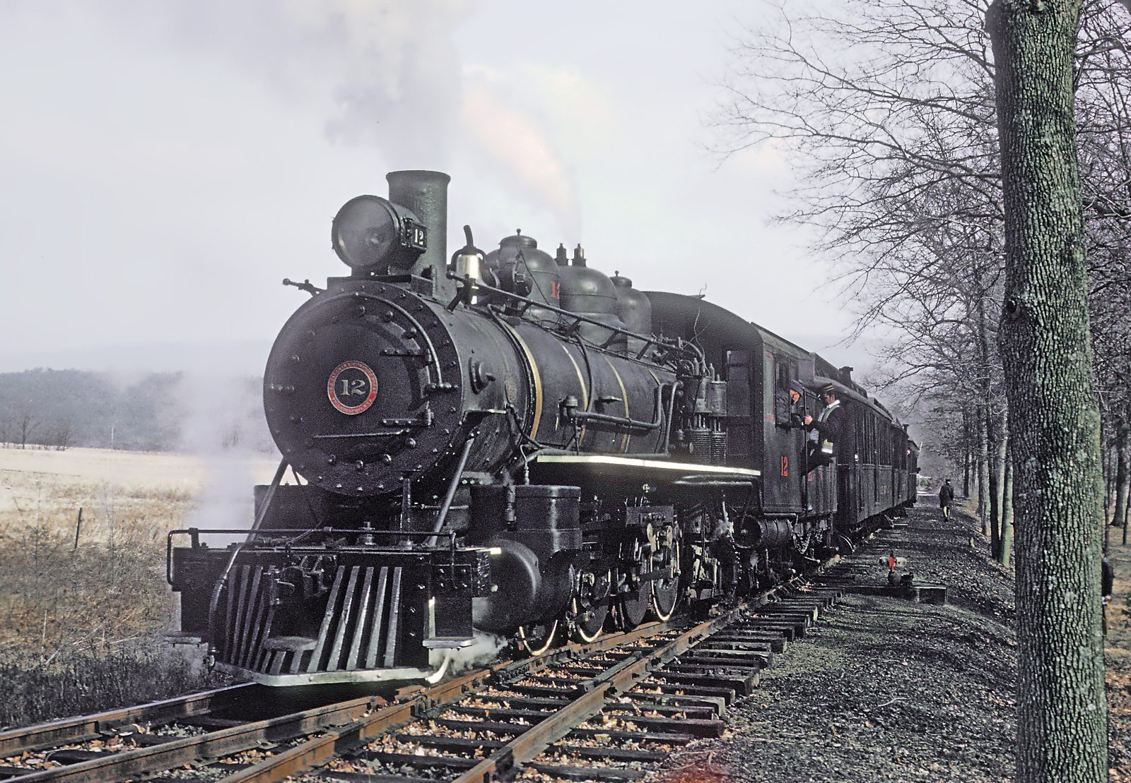
The East Broad Top Railroad opened eleven miles of track from Mount Union to Orbisonia in 1873 and completed its route the following year. Shirleysburg gained a passenger and freight depot, connecting local residents and farm products with the Pennsylvania Railroad at Mount Union.
East Broad Top locomotive No. 12 on the wye near Shirleysburg during the railroad’s tourist-excursion era. From the BricktownPA community photograph collection.
1880s
A Stable Rural Center
Shirleysburg’s population held near 300. Four stores, groceries, taverns, two potteries, a gristmill and a steam tannery served the town and surrounding farms.
Market Connections
From Grain to Dairying
Improved transportation gave local farmers better access to regional markets. Many shifted from grain toward dairying, producing hay and corn to support larger cattle herds.
1956–Present
Freight Ends, Heritage Remains
Regular East Broad Top freight service ended in 1956. Tourist trains later ran to the Colgate Grove wye south of Shirleysburg, keeping the borough connected to one of Pennsylvania’s best-known historic railroads.
Preserving Shirleysburg
A Small Borough With a Long Memory
Twentieth-century automobiles drew commerce toward larger towns, while the decline of Broad Top coal ended the railroad’s freight era. Because relatively little new development followed, Shirleysburg retained much of the scale and appearance of its nineteenth-century village landscape.
Fort Shirley Heritage Association
Founded from the community’s 1976 bicentennial effort, the association operates a museum in a log building opened in 1981. Its holdings include local family and property research, church records, pottery, tools, Native American artifacts, Shirleysburg Herald issues and a replica of Croghan’s trading post.
Researching Families and Properties
The association preserves Dr. McKnight’s birth records for 1860–1875 and death records for 1865–1872. Pennsylvania State Archives guides also identify Shirley Township tax assessments beginning in 1788 and Shirleysburg borough assessments for 1855–1876.
J. Simpson Africa, “Borough of Shirleysburg”, in History of Huntingdon and Blair Counties, Pennsylvania (1883), transcribed by Huntingdon County PAGenWeb.
Historic American Buildings Survey, Walker Farmstead, HABS No. PA-6086, Library of Congress, especially the regional history on pp. 2–3.
Titus R. Wingert, First Man Hanged in Huntingdon County: The Brown Family Tragedy and Other Assorted Tales, digitized archival edition supplied to BrickTownPA, original pp. 141–143. The Shirleysburg chapter is a modern local-history synthesis and is used here to connect the borough with the documented Brown case, not as a substitute for the earlier borough and court records.
Research note: Early accounts sometimes confuse Aughwick with Little Aughwick or use several names for nearby places. This page follows the location distinctions made in the 1883 county history and identifies approximate fort-site language accordingly.
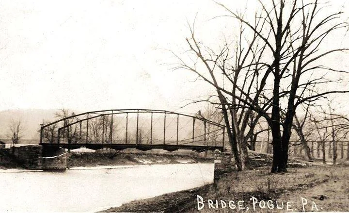
Shirleysburg and nearby Pogue
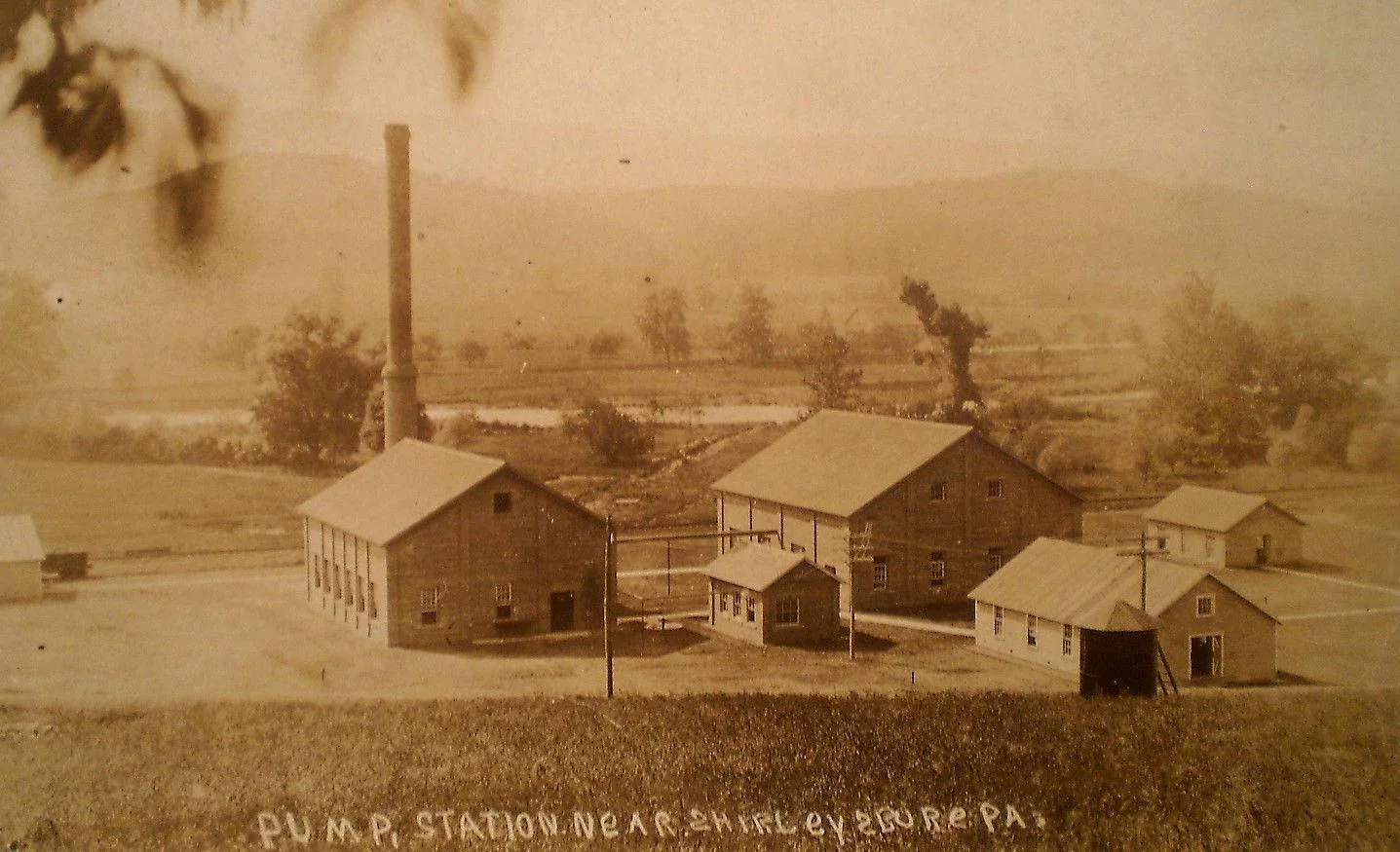
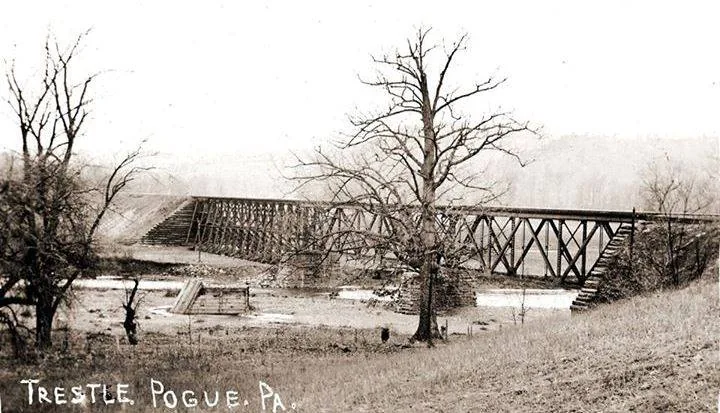
Presbyterian Church, Shirleysburg. Date unknown.Photographs submitted by Chris Hughes / Dwight Rittenhouse.Caption and source notesPump station near Shirleysburg. Date unknown.Photographs submitted by Chris Hughes / Dwight Rittenhouse.Caption and source notesRailroad trestle at Pogue. Date unknown.Photographs submitted by Chris Hughes / Dwight Rittenhouse.Caption and source notesBridge at Pogue. Date unknown.Photographs submitted by Chris Hughes / Dwight Rittenhouse.Caption and source notes
Fort Shirley Heritage Association reported 28 museum visitors and 80 visitors to schoolhouse displays during the September 19 Tractor Show and Free Museum Day. These are separate attendance counts, not a count of unique visitors.
Lena Mae (Cisney) Berrier’s October 9 obituary reports that she and Dean Alexander Berrier managed a Shirleysburg general store from 1945 to 1947. The store’s name, street address and ownership are not identified; directories, advertisements and family photographs could help establish them.
Source: The Daily News, October 15, p. 2, Ron Morgan; October 9, p. 2, Lena Mae Berrier obituary.