The St. Patrick’s Day Flood
The Flood of 1936 was not one isolated incident along the river. It interrupted transportation and communication, inundated homes and businesses, damaged recreation and industrial properties, destroyed a quarry railroad bridge, and turned Mount Union’s schools, churches and civic organizations toward relief work.
Snow, Frozen Ground and Sustained Rain
A Basin Ready to Flood
A cold, snowy winter left deep snowpack and frozen ground across Pennsylvania. When warmer weather and repeated rain arrived in mid-March, melting snow and rainfall ran rapidly into streams and rivers instead of soaking into the soil.
A Statewide Disaster
The resulting St. Patrick’s Day floods affected waterways across Pennsylvania. Along the Juniata, the flood reached its documented high point at Huntingdon on March 18, producing a floodmark of 21.87 feet and an estimated discharge of 81,000 cubic feet per second.
Isolation, Inundation and Rescue
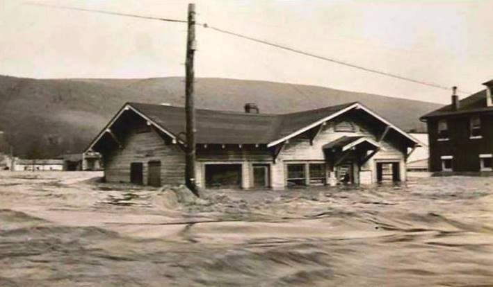
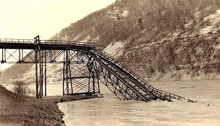
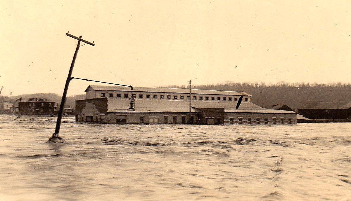
A 1967 Daily News retrospective described the flood as Mount Union’s worst disaster. It reported that electric lights, telephones, railroad service and principal roads were lost as water entered the borough. The Long Lumber Company was inundated, the Juniata Valley Colony Club property was devastated, and the Harbison-Walker dinky bridge across the Juniata was swept away. Schools, churches and other community buildings became part of the relief response.
The retrospective was written thirty-one years after the disaster. Its specific local account is preserved here with attribution, while river measurements and later flood-control information are separately checked against government records.
What the Newspapers Recorded in March 1936
Contemporary coverage separates what residents knew during the emergency from what the community remembered decades later.
North Mount Union Among the Hardest Hit
The flood-special front page of The Daily News described Huntingdon County as marooned by failures of highways, railroads, electricity and telephone service. It specifically named North Mount Union among the communities that “bore the brunt” of the damage and ran the subheadline, “Mount Union Suffers Severe Damage.”
Relief, Return and Loss
The paper’s Mount Union column recorded people returning to check on relatives and property. Mrs. Leroy Streeter, identified as former resident Helen Chilcott, traveled from Philadelphia with a car of food and provisions after hearing radio reports of conditions in Mount Union. The same column reported that a summer home at the Juniata Valley Colony at the Country Club had been swept away with its contents, leaving its foundation and stone walk.
Relief, Rebuilding and a Devastated North Side
The March 26, 1936, Mount Union Times devoted its front page and several continuations to the flood. Together, those reports show a community still clearing mud, housing displaced families and restoring basic services while trying to measure enormous losses.
Schools Became Shelter, Kitchen and Hospital
The local Red Cross registered 160 families—estimated by the paper at approximately 800 people—at its Market and Jefferson streets office. Temporary sleeping quarters, a kitchen and an emergency hospital were established in the Grade School auditorium and gymnasium. The feeding operation served about 400 people per meal during the crisis before falling to 85 as families found shelter. Fifteen patients were treated at the school-based emergency hospital.
A National Red Cross clothing shipment valued at $3,000 arrived for local distribution. The local emergency flood committee raised $1,050.25, largely in a single day, and turned the money over to the Red Cross.
Mud, Lost Lumber and Buildings Torn Loose
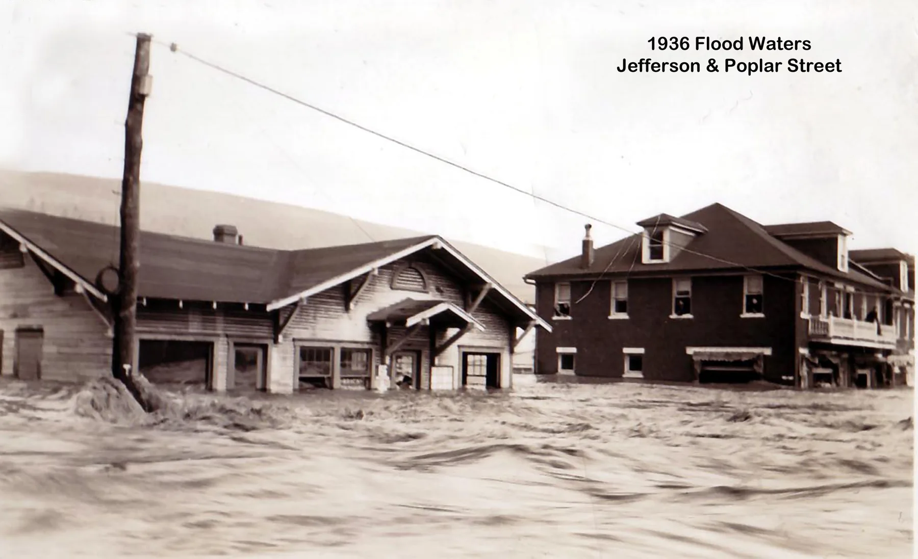
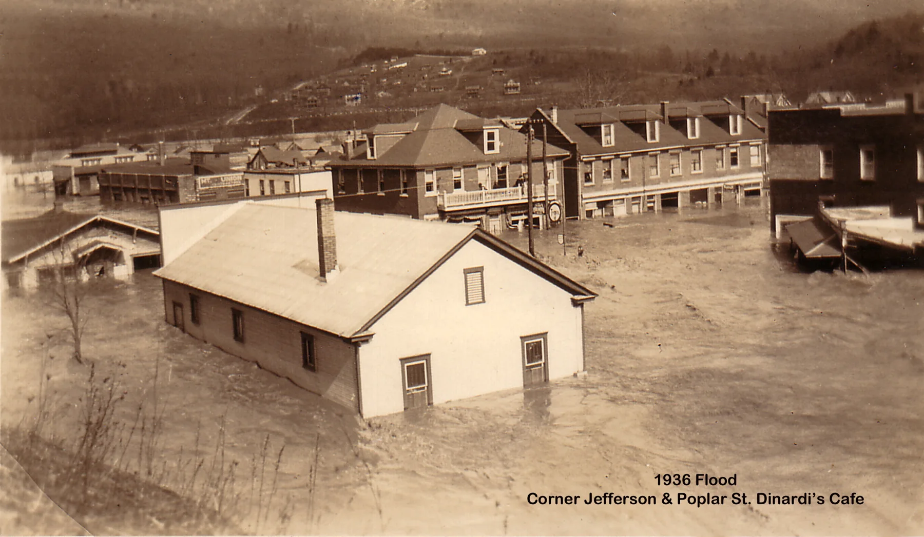
The paper described the Long and Fetterolf lumber operations as among the North Side’s most seriously damaged properties. Lumber was swept away, electrical motors were ruined and buildings filled with mud. At Poplar and Jefferson streets, floodwater lifted an office building from its site, carried it across Jefferson Street and drove it into a restaurant, knocking that building from its foundation and into Poplar Street.
Fetterolf’s restaurant annex and planing-mill property also suffered extensive losses. At the Mount Union Ice Company, the paper reported that the full damage could not yet be estimated while mud remained inside.
Emergency Service Returned Within Twelve Hours
The borough water works was badly damaged, but emergency service was restored to every section of town within twelve hours. Because pressure remained unreliable and contamination was a concern, residents were told to conserve water and boil water used in the home. The notice is a reminder that recovery involved public-health risks as well as visible property damage.
Men and Equipment Sent Into the Flood Zone
Approximately 125 men from Civilian Conservation Corps camp S-58 were assigned to Mount Union and Newton Hamilton with trucks, a tractor and other equipment. Their work included clearing roads and trails, removing debris from waterways and helping with sanitation. A separate emergency clinic associated with the CCC response at North American Refractories reported treating approximately 600 people for exposure, shock and respiratory illness.
The Colony Club Was Nearly Erased
Follow the cottage families, failed sale and Legion recovery in the full Colony Club story.
The Mount Union Times called the Juniata Valley Colony Club the most completely demolished place in the area. Most cottages and homes were swept downstream; the structures that remained were badly damaged by debris and mud. The paper identified the Cherry cottage and Derrick residence as the only two summer homes still standing on the riverbank and described empty foundations, household goods scattered through the grounds and trees hung with mud-caked clothing.
A Club Archive Was Destroyed
A filing cabinet containing the Colony Club’s business records was recovered about 200 yards downstream. The water-soaked papers were unreadable, and the club typewriter was reported damaged beyond repair. The loss helps explain why the surviving newspaper account is especially valuable to reconstructing the club’s history.
Guards, Cleanup Crews and Returning Owners
Property owners returned to search for belongings and hired workers to clear mud and debris. National Guardsmen were posted at the grounds after thefts were reported. Across town, the March 26 issue also reported that Mount Union schools were scheduled to reopen and that two Pennsylvania Railroad through tracks had returned to service through the flood-damaged corridor.
More Than $50,000 in Damage at North American Refractories
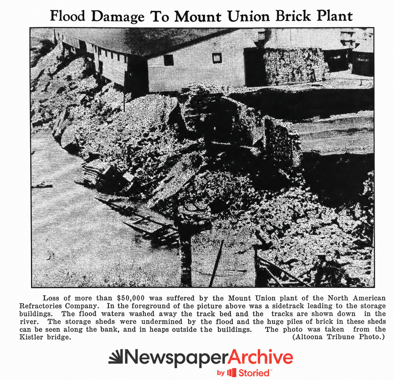
A photograph published on March 26 documented the damage at the Mount Union plant of the North American Refractories Company. Its caption placed the loss at more than $50,000. The plant had opened in 1911–12 as Mount Union Refractories, became U.S. Refractories in 1922 and joined North American Refractories in 1930.
The caption described a sidetrack that had led to the storage buildings. Floodwater washed away the track bed and left the rails down in the river. Storage sheds were undermined, while large piles of finished brick were scattered along the bank and outside the buildings. The photograph was taken from the Kistler bridge.
The Flat and Unequal Exposure
Mount Union’s northern third occupies the Juniata River’s low floodplain. The 1994 National Register nomination records that many Black residents lived in the low-lying neighborhood north of the railroad viaduct known as “The Flat,” an area flooded badly in both 1936 and 1972. The March 26, 1936, relief report separately stated that, when the school sleeping quarters closed, 35 Black families were transferred to churches in the Flat. That contemporary account shows that the town’s emergency response operated within the segregated social arrangements of the era. The flood is therefore more than a story about damaged structures: it is also part of the history of where housing was available, which families lived closest to the water and how race and development patterns shaped exposure and recovery.
Mount Union Under Water
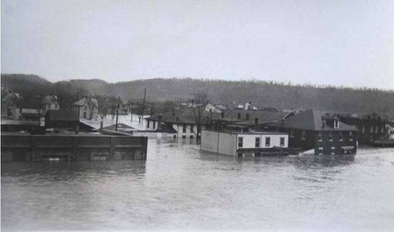
These photographs preserve the scale of the inundation, the force of the current and the damage to the industrial transportation system. Locations are described only as specifically as the surviving captions allow.
The Dinky Bridge and the Thousand Steps
The loss of the dinky bridge severed a vital link in the small industrial railroad system that moved ganister from Jacks Mountain to Mount Union’s refractory plants. The Thousand Steps were constructed by Harbison-Walker employees around 1936 and have long been associated with the industrial disruption that followed the flood. The surviving trail sign confirms the approximate construction date and the builders, but it does not by itself establish every detail of the often-repeated flood origin story.
The Thousand Steps
The quarry, inclines, dinky railroad and workers’ stone staircase.
Railroads & Bridges
The transportation network the flood interrupted.
Blue Springs & Beacon Lodge
The river estate, Colony Club connection and lost bridge.
Flood Protection and a Changed River
The St. Patrick’s Day Flood isolated the borough and damaged residential, commercial, recreational and industrial property.
A flood-protection levee was constructed along the Juniata River upstream from the U.S. Route 522 bridge.
Flooding associated with Hurricane Agnes became Mount Union’s maximum flood of record, surpassing 1936 and again inundating low-lying areas.
The Mount Union levee was raised and extended at its upper end. Huntingdon County’s hazard plan says it protects the area between Filbert Street, North Washington Street and the levee from the Juniata’s 100-year flood.
Raystown Dam reduces the modeled 100-year flood elevation at Mount Union by an average of approximately 2.5 feet, but the Juniata River and Hill Valley Creek remain central to the borough’s flood-risk planning.
Help Identify the Flood Photographs
If you recognize a building, street, business or person in these images, please share the identification and how you know it. Community knowledge is welcome, but proposed identifications will be labeled as such until they can be corroborated.
Sources and Further Reading
- The Daily News, June 6, 1967, Mount Union Centennial Edition, viewer p. 22; retrospective account and local damage photographs.
- The Daily News, March 18, 1936, p. 1; contemporary flood special, county isolation and North Mount Union damage.
- The Daily News, March 24, 1936, p. 10; Mount Union relief, return travel and Country Club-area property loss.
- The Daily News, March 26, 1936, p. 10; North American Refractories damage photograph and caption.
- Mount Union Times, March 26, 1936, p. 1; local business losses, Colony Club destruction, water service, Red Cross registration and emergency shelter.
- Mount Union Times, March 26, 1936, p. 4; railroad recovery and the scheduled reopening of Mount Union schools.
- Mount Union Times, March 26, 1936, p. 5; Red Cross supplies, contributions and emergency-hospital continuation.
- Mount Union Times, March 26, 1936, p. 9; local recovery, Colony Club, flood committee and CCC continuations.
- Kim E. Wallace, Brickyard Towns: A History of Refractories Industry Communities in South-Central Pennsylvania (National Park Service, 1993), printed pp. 105 and 132–133; North American Refractories plant history.
- National Weather Service, “Flooding in Pennsylvania”; statewide causes and chronology.
- U.S. Geological Survey, Water Resources Data, Pennsylvania, Water Year 2002, Volume 2; historic Huntingdon floodmark and discharge.
- Huntingdon County Multi-Jurisdictional Hazard Mitigation Plan, Mount Union Borough flood profile; levee, 1972 flood and Raystown Dam context.
- Frederick L. Richards, “Mount Union Historic District” (National Register of Historic Places nomination, 1994); the floodplain, the Flat and historic housing patterns.
- Standing Stone Trail Club, history of the trail in pictures; quarry and trail context.